Did You Know? Interesting Facts about Klamath County
When you visit Klamath County, you might gaze upon Crater Lake, bask in the region’s sunshine, or visit historic sites. And while these elements help make the region a special place, knowing why they make it so special can deepen your appreciation and enjoyment of all Klamath County has to offer.
For instance: Did you know that Crater Lake is the deepest lake in the United States, that Lava Beds National Monument is important for reasons both natural and cultural—and that there isn’t technically a waterfall called “Klamath Falls”?
It’s all true. Brush up for your next pub trivia night with these interesting facts about Klamath County.
Technically, There is no Klamath Falls
The modern-day Link River was known as Eulalona to the native Klamath—a lyrically beautiful word meaning “to move back and forth,” named after the effect that strong winds regularly had on the water. Discover Klamath
It’s an assumption visitors have made for decades: The city is named Klamath Falls, so there must be a waterfall of the same name, right?
Turns out, that’s not exactly the case. As it happens, the city is technically named for a series of rapids and low-lying falls in the two-mile-long Link River—so named because it “links” Upper Klamath Lake and Lake Ewauna just west of downtown Klamath Falls. (You might also see the name of the river on map apps listed as “Klamath River.”) These low-lying falls are named Link River Falls.
A hydroelectric dam in the river eliminated some of the rapids, though some remain visible, especially at periods of high water, today; the falls are best explored from along a mostly flat hiking trail that hugs the Link River. And if you’re still curious about thundering cascades in the region, check out our guide to waterfalls near Klamath Falls.
You Can Hike On (and Inside) the Largest Volcano in the Cascade Range
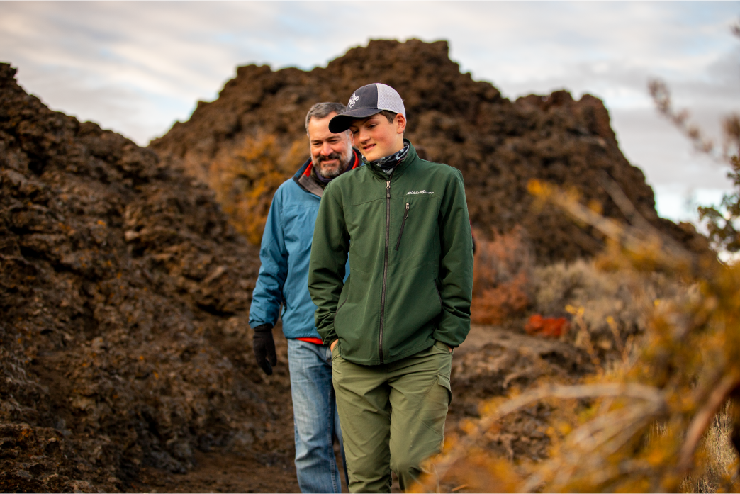
Hiking above or below ground at Lava Beds National Monument is a favorite for many locals. Discover Klamath
Best of all: You don’t even need to climb a mountain to do it.
The Lava Beds National Monument sits at the southern edge of the Klamath Basin—and atop the Medicine Lake shield volcano, which at 144 cubic miles, is the largest volcano (by volume) in the Cascade Range. Befitting its name, the volcano doesn’t ascend to a pointed peak (like Mount Shasta)—but resembles a, well, shield with its broad reach and gentle slopes. Medicine Lake Volcano has been erupting and emitting lava flows, on and off, for some 500,000 years—with the most recent eruption taking place just 950 years ago. (Medicine Lake is still technically an active volcano today, but it is considered dormant by geologists.)
Over the centuries, underground lava tubes have formed during and after those eruptions, creating a network of more than 800 underground caves—24 of which can be explored today. So, yes: It’s possible to hike inside an ancient volcano and follow the paths of long-ago lava flows. Learn more about caving at Lava Beds National Monument.
The Klamath Basin is a Birding Paradise
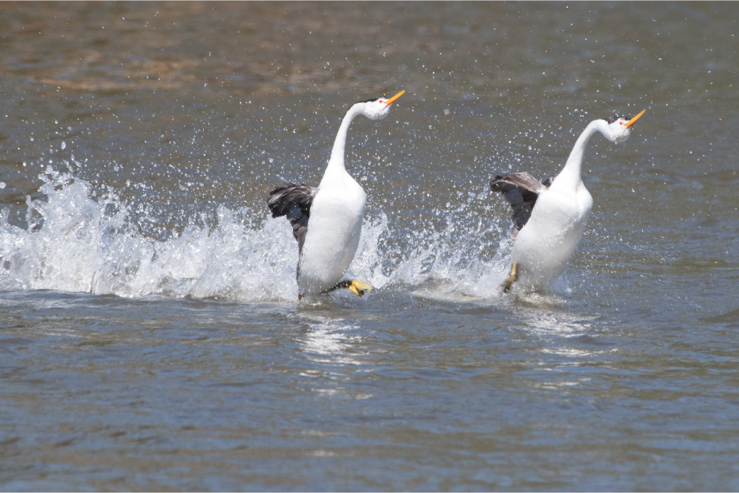
During mating season, grebes engage in a maneuver called rushing in which they can sprint up to 60 feet across the water in about seven seconds. The best time to view rushing in Klamath Falls is late March through May at Putnam Point. Becky Matsubara
You might have heard that the Klamath Basin is a bucket-list destination for birders from around the world—but why is that?
Turns out, our birding acclaim comes from two factors: The region is home to excellent ecosystems suited to migrating birds, and an ongoing effort to preserve public lands has ensured those birds—more than one million of which pass through Klamath County each year—have habitats to rest, nest, and feed.
For starters, Klamath County is in the heart of the Pacific Flyway, a major migratory bird route between the arctic tundra of Alaska and the rainforests of Argentina. Roughly a billion birds in all use the Pacific Flyway, with a small percentage of those making it to the Klamath Basin on their annual migrations. (Learn all about some of the most common birds you might see in Klamath County.)
The birds that do pass through—roughly 350 species have been identified in Klamath County—enjoy a wide variety of protected ecosystems in the region. In all, six national wildlife refuges comprise roughly 200,000 acres of forests, wetlands, meadows, waterways, and other vital habitats that accommodate the needs of various species. Each winter, for instance, roughly 500 bald eagles nest and feed around the Lower Klamath National Wildlife Refuge at the southern edge of the Klamath Basin.
For more, check out our ultimate guide to the world-class birding scene in Klamath County, and plan your outing along the Klamath Basin Birding Trail.
Crater Lake is the Deepest Lake in the United States
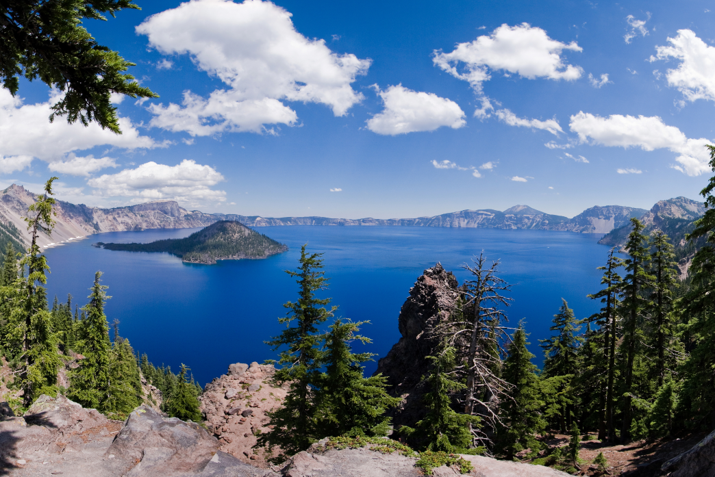
Once Mount Mazama, which rose 12,000 feet over the surrounding Klamath Basin and erupted about 7,700 years ago, and the volcano’s walls eventually collapsed, leaving behind a bowl-shaped caldera that over the years filled with rainwater and snowmelt. Discover Klamath
We could write an entire blog post of fun facts about Crater Lake National Park: It’s Oregon’s only national park, was established in 1902, and receives an astounding 43 feet of snow each year.
Another fascinating bit of trivia: Measuring 1,943 feet at its bottommost point, Crater Lake is also the deepest lake in the United States. (So deep is Crater Lake, you could drop the Empire State Building into the bottom of the lake—and still have roughly 700 feet of depth to spare.) Today, you can enjoy the lake from along the 33-mile Rim Drive or hike to the surface at Cleetwood Cove and take a boat tour—the only safe and legal way to get on the water.
Learn more with our complete guide to Crater Lake National Park, and get the skinny on six must-see attractions near Crater Lake.
Downtown Klamath Falls is Heated by Geothermal Energy
Klamath Falls receives about three feet of snow each year, with most of that falling between November and February. Yet while you might see surrounding forests blanketed in white and snowy streets around Klamath Falls, chances are good you’ll enjoy snow-free bridges and sidewalks crisscrossing downtown.
That’s because the city Klamath Falls powers several downtown buildings and key infrastructure via two wells filled with geothermal water. This water, which hovers around 200ºF, flows through up to two miles of pipeline just under city streets—a process that keeps several buildings powered and sidewalks snow- and ice-free all winter long.
That means, no matter the weather, you can safely take a historic walking tour of downtown Klamath Falls, easily view public art in Klamath Falls, and enjoy some of the city’s best restaurants and brewpubs.
Klamath Falls is “Oregon’s City of Sunshine”
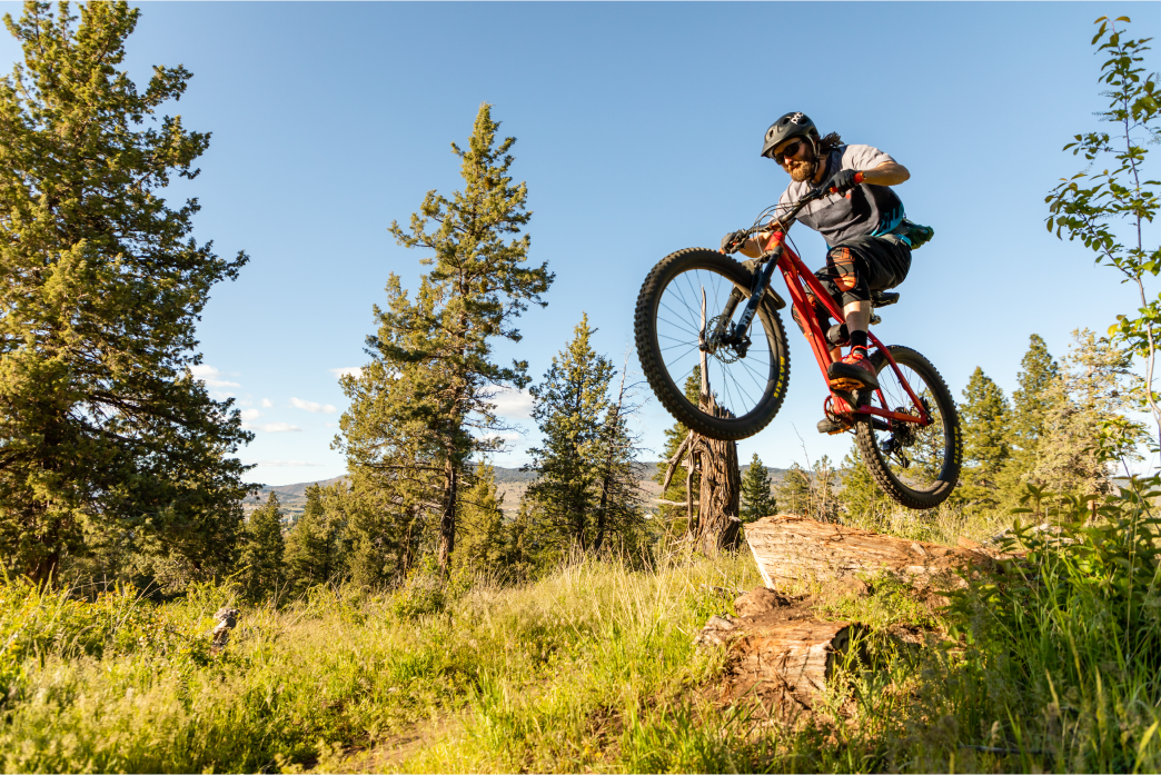
Constant sunny skies provide an abundance of perfect mountain biking days on the Moore Park Trail System. Discover Klamath
Did you know Klamath Falls is the sunniest city in Oregon?
It’s true: Sitting at the eastern edge of the Cascade Range and in the heart of the Klamath Basin, Klamath Falls enjoys more than 300 days of sunshine per year—and just 10 inches of rain annually. With such a sunny climate, you can expect high temperatures of around 80-85ºF in summer, 55-75ºF in fall, 40-50ºF in winter, and 55-70ºF in spring.
That makes the city an excellent base camp for four seasons of outdoor adventure—like snowmobiling more than 165 miles of trails, bird-watching at Upper Klamath Lake, hiking the Sky Lakes Wilderness, zipping across the treetops with Crater Lake Zipline, and more.
A Sad Chapter of World War II History Took Place Near Klamath Falls
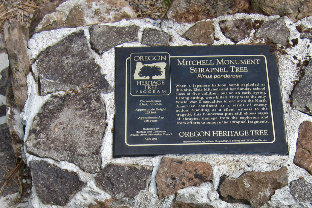
Delve into the history of the Japanese balloon bombs at the Klamath County Museum before traveling to the Mitchell Monument. Michael McCullough
The Klamath Basin is home to a lot of storied history, but it’s also the sight of a heartbreaking tragedy during World War II.
During the war, Japanese forces created about 9,000 “balloon bombs” that were filled with hydrogen gas, tied to a basket, armed with bombs, and sent into the jet stream—hoping the balloons would sail across the Pacific Ocean and land in the United States. The ultimate goal was to start fires, diverting attention from the war effort, and creating mass panic across the country.
Of all the bombs to make landfall, however, just one claimed the lives of United States citizens. It was discovered on May 5, 1945, near the community of Bly and just one hour east of Klamath Falls.
On that day, minister Archie Mitchell, his pregnant wife, Elsie, and five children from their Sunday school class were enjoying a picnic in the forest. Elsie and the children, scurrying to the picnic site while Mitchell parked the car, discovered and accidentally detonated the bomb—and were killed when it exploded. It was the only time Americans were killed by enemy fire in the continental United States during World War II.
Today, the Mitchell Monument Historic Site is noted by a stone marker with a bronze plaque where the tragedy occurred; it is accessible between mid-May and mid-September each year. Shrapnel from the bomb is even still embedded in the surrounding trees, many of which were burned in the 2021 Bootleg Fire. Learn more about the Mitchell Monument and the Japanese balloon bombs.
You Can Hike on Old Battlefields at the Lava Beds National Monument
The Lava Beds National Monument isn’t just famous as a massive volcano; it’s also an important site rich with cultural history, as well.
In November 1872, the Lava Beds were the site of a stronghold at the heart of the Modoc War of 1872-73.
The seeds for war had been planted three decades earlier, when the region’s first European-American settlers began moving into territory belonging to the Modoc people. Tensions continued to rise over the subsequent years, and a misunderstanding between the Modoc people and the United States led to the start of the war in late 1872.
Soon after an early battle, a group of Modocs led by Kintpuash—who’d earn regional fame under the name Captain Jack—retreated to the lava beds on the northeastern flank of Medicine Lake Volcano. This stronghold, on the site of their ancestral homeland, gave the Modocs a crucial advantage; they maintained their position in the present-day Lava Beds National Monument for several months, while the U.S. troops were confused by the maze-like nature of the lava flows.
Today, you can get a feel for that history along the 1.5-mile Captain Jack’s Stronghold trail, which heads through sites from the battle in the midst of a massive lava flow.
And if your curiosity is piqued, listen to The Modoc War: A Homeland Lost, an audio tour available via the VoiceMap™ mobile app. The audio tour, which begins in Klamath Falls, is narrated by Modoc descendant Cheewa James; along the way, James shares the roots of the war, stories of the Modocs, and tales of what life was like in the 1870s.
Learn more about the Lava Beds and other essential adventures you can only have in Klamath County.
